We can use this thread to post sneak peaks of the 7th Sea 2nd Edition (unless non-disclosure clauses prevent this).
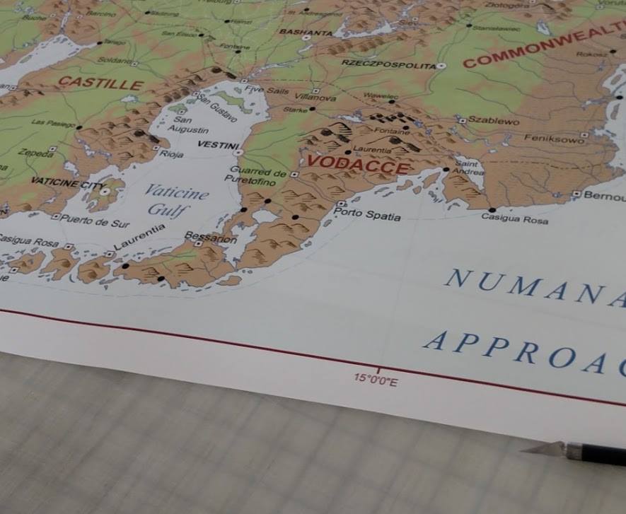
This is a map printed out by Fabien Badilla. John Wick posted it too, so it seems legit. 

—
TAJ-07: Technopriest And Justicar Of 7thSea2e


Woohoo! That looks awesome.
Just a side note, I really hope the maps include a scale.
Nope. Sorry, Salamanca. If you are going to give me nice pretty maps to work with, don't cheat on the scale. Sometimes it's important. You can still handwave the road trip.
This is just begging for this quote: "It's 106 miles to Chicago, we got a full tank of gas, half a pack of cigarettes, it's dark... and we're wearing sunglasses."
Not to mention we are talking about a continent that does not have modern concrete highways everywhere. There are roads, but sometimes due to difficulty of terrain the roads are not as straight as they should be. Travel between two major cities usually has a main highway to travel unless it has to go through a mountain range or one particular bridge over a main river. Not so major towns might not have highways left by the Numan empire, nor newly built cobbled roads, but ordinary dirt roads that are windy, difficult to travel in rain or snow, and quite dangerous at night (hence the numerous inns and taverns springing up at this time as way stops for travellers so they don't have to deal with bandits attacking their camps).
Often times if I wanted my adventurers to move quicker I mention that they take a river boat or find passage on a ship from at least part of the journey. But if I want them to move slower I mention the winding roads, hard to navigate steep hills/mountains, and the easily treachorous thick woods. This is why most adventuring RPGs have checks you make while travelling (like sense direction/survival or knowledge (local)).
So if a GM wants an encounter to happen, no matter the distance involved, it can happen.
Scale is very important. I can always slow a journey or speed it up but when the numbers become critical, I like having hard numbers.
“Every normal man must be tempted at times to spit on his hands, hoist the black flag, and begin to slit throats.”
- H.L. Mencken
On travel during the analogous historical period here on Earth:
"Parenthetically it may be mentioned here that neither gunlocks nor any new invention, school of thought, artistic movement or other innovation spread very fast in these times. There were few roads, and such as there were teemed with murderers, became axel-deep ribbons of mud in spring and turned into glaciers of snow and ice in winter. There was as yet no such thing as scheduled or public transportation. The rich traveled in their own coaches with armed escort; others road horseback; the poor (95% of the population) walked. Under the most ideal conditions, Nuremberg lay fourteen hazardous, bone-rattling days north of Venice by wagon. Eighteen days was good sailing time from Venice to Alexandria across the pirate-infested Adriatic and Mediterranean. A fast courier could bring news from Paris to Buckingham Palace in just a little over two days if he forswore sleep for a day and a half between Paris and Calais, but normal traveling time over the same route was three days. The sea route from Portsmouth to Naples could be covered, with luck, in a month - if storms and virulent fever didn't decimate the passengers and crew, if pirates didn't slaughter or sell all into slavery, or if the Inquisition didn't capture and burn the Protestants aboard. To a journeyman gunsmith, Rotterdam was three footsore weeks from Bremen and over six from Nuremberg. The Italian boot from Milan to Reggio was twenty one days long by coach and two months long by foot- with chances of survival getting poorer and poorer with every bend in the road south of Benevento."
- Robert Held, The Age of Firearms
“Every normal man must be tempted at times to spit on his hands, hoist the black flag, and begin to slit throats.”
- H.L. Mencken
And even travel by sea could vary -- look at the times for an Atlantic crossing.
In the early 19th century sailing ships took about six weeks to cross the Atlantic. With adverse winds or bad weather the journey could take as long as fourteen weeks. When this happened passengers would often run short of provisions.
Morgan Wolfe
aka Capt. Doña Sir Kestrel of Avalon http://silver-gateway.com/7sea/
I think one thing we should notice is we are not seeing a Montaigne invasion of Castille marked on the map. So if there is a war between the two nations, it is probably not that far along.
Also, we are seeing a lot of familiar place names from 1st edition in different places, but a lot of different ones as well. One thing I am thankful for is that not every Vodacce principality's capital is an island. We see Vestini, Bernouli, and Villanova with capitals on the mainland. At the same time we seem to have a repeat of the island capital-mainly holdings motif with the new faction of Laurentia.
This map has caused me to think of a few more things about Vodacce but I'll spill that out in a different, more relevant thread. One thing I am seeing is that Castille and Vodacce are a lot closer together so I am curious if we are to see some mixing like what happened with Naples and Sardinia.